Dowsing Archaeological Features;
An empirical study at Cressing Temple, Witham, Essex.
(TL799187).
14. Topology of the site from Maps. (Figures. 12a-b).


12a-b. Click for legible images.
Chapman and Andre. (Figure. 13).
13. Chapman and Andre's map of 1777 showing the location of
Cressing Temple. Its low resolution means that the buildings are only vaguely
reflected in form. It may be, of course, that they were not allowed on the
farm to complete the survey and so produced their views from the roadside.
The earliest map known showing the site of Cressing Temple is that of Chapman and Andre published in 1777 as part of a compendium of the County of Essex. Although it clearly locates the curtilage the small scale perforce gives little detail and may even be inclined to mislead. The Walled Garden appears with the farmhouse but the two great barns and the moats are indiscernable. Interestingly there are two buildings near the road and the pond is clearly depicted. What can be firmly stated however is that there is no 'Greate House' here at this time.
1794 Estate Map. (Figure. 14).

14. The estate map of 1794. Produced in colour on vellum for
Lady Waltham. The buildings by the road noteworthy as they no longer exist
by the time of the first Ordnance Survey.
This is a coloured map penned on vellum and in the protection of the Essex Record Office (ERO;T/M 529). Commissioned by Lady Waltham it shows the lands surrounding in the ownership or under lease to John Olmius and Mr Grimwood, names both synonymous with the development of Cressing Temple. The Walled Garden, moats, barns and farmhouse are all clearly shown as is the Granary and the Craft Barn (known to be an unusual type of C18th aisled barn). The buildings by the road are still in place and there appears to be building or pen on the road itself. The south arm of the east moat is not shown and neither is the horse pond. There is an entrance to the barnyard from the north.
1842 Tithe Map. (Figures. 15a-b).

15a. The 1842 Tithe Award map is clinically penned and the
accurate acreages in the Tithe records indicate that a fully measured survey
was carried out of all the properties. Where it still shares the same topography
as the site today it is seen to be reasonably accurate.
Click on 15b for a legible image.
The tithe survey map published in 1842 shows a significant change in the site. The south-east arm of the moat is shown full of water and the horse pond is dug out with the wagon lodge forming its western flank as it does today. The moat pond near the farmhouse is present and the north entrance is still in use and listed as Occupation Road. Fences have been added to enclose the farmhouse garden. The Wheat Barn is drawn curiously implying an outhouse on its eastern end.
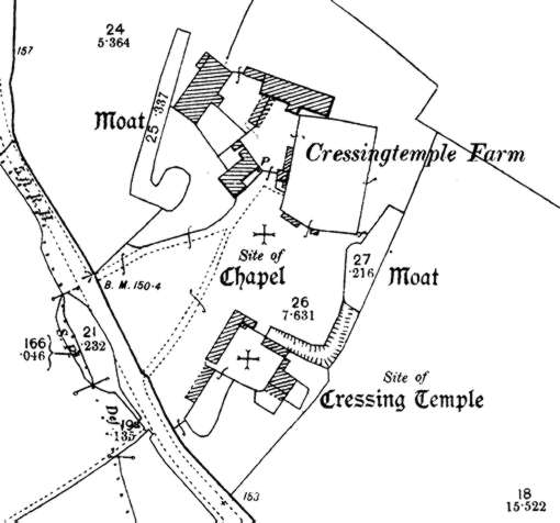
1876 Ordnance Survey. (Figure. 16).

16. The 1876 Ordnance Survey is probably one of the most detailed
maps of Cressing Temple and its accuracy is demonstrated to be high.
This is the most detailed survey available as it shows not only the disposition of the buildings but of the trees and ruins. It clearly marks the 'site of the chapel' and the 'site of Cressing Temple'. The site of the chapel is close enough and would have been visible as low walls (albeit the Tudor adjuncts) but there seems to be no reasoning behind the siting of Cressing Temple in the farmyard. All evidence otherwise seems to disprove this. At the time there must have either been some visible footings or some local hearsay.
The barns now have their stock sheds and the small brewhouse behind the farmhouse has appeared. The farmhouse has been extended to include a bread oven and a coal house on its north-east end. The dairy has been built against the Walled Garden in the stock yard. The well is shown in front of the farmhouse and an enclosure has been put up around the south of the Walled Garden. The Garden itself is shown landscaped with orchards. The large tree in the north-east corner is still there and is a walnut.
The moats are now labelled as such and the south-east moat arm is shown present but dry. The horse pond, known to be connected by a culvert to the south-east arm, is planned in. The west moat now has its pond and the Barley Barn has had the Roller Shed attached to its north corner. In the farmyard complex the horse shelter has appeared along with the fences for the colt yards and the piggeries. The wagon lodge is now present in line with the Granary and it is suspected that it was moved here from its earlier position near the road as it is clearly an C18 building. The other buildings near the road are gone and two drives now service the farmhouse.
1894 Ordnance Survey. (Figure. 17).
17. The 1894 Ordnance Survey is less detailed than its predecessor
of 1876 but it shows that some small changes took place over the twenty year
period. From now on the site remains relatively unchanged until the mid-1970's.
The site deteriorated with the loss of two of the buildings.
There is unsurprisingly little change in the twenty year interval but the style of the map has altered and no longer reflects the landscaping so assiduously. One of the stock sheds has gone, no doubt a victim to the poor drainage on this part of the site. The well is replaced by a pump and a wall closes off the south of the Walled Garden flanked by two small outhouses known to be latrines. In the farmyard the stallion box is built and also a small annex to the granary thought to be a staircase to the grain floor.
From this point on no major changes affected the site. In the C20th water and electrical services were laid in but these are recorded on the site service plan.
15. Excavation history of the site.
![]()
Barry Hillman-Crouch. MSt PA, Dip FA, BSc, HND. Written 1999 Published on the web June 2005.